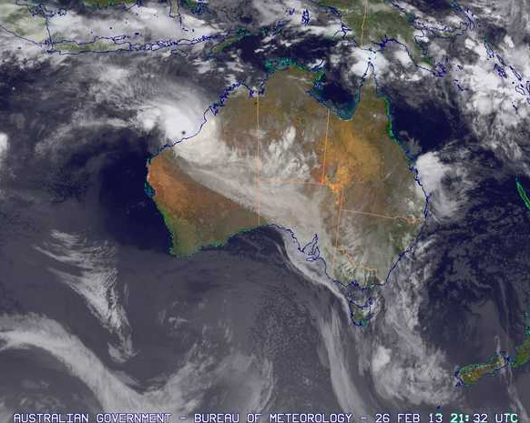
The BOM just issued the following warning:
TROPICAL CYCLONE ADVICE NUMBER 30
Issued at 5:36 am WST on Wednesday 27 February 2013A Cyclone WARNING is current for coastal areas from Bidyadanga to Mardie including Port Hedland, Karratha and Dampier, and adjacent inland areas of the Pilbara, including Marble Bar, Nullagine, Millstream and Tom Price. A Cyclone WATCH is current for remaining central and eastern areas of the Pilbara including Newman, Telfer and adjacent parts of the Gascoyne district.
At 5:00 am WST Severe Tropical Cyclone Rusty, Category 4 was estimated to be 130 kilometres north northeast of Port Hedland and 290 kilometres east northeast of Karratha and is near stationary.
Severe Tropical Cyclone Rusty has been near stationary overnight but is expected to resume a southerly track towards the Pilbara coast during the day. The slow motion and large size of Rusty means that the destructive and very destructive winds will occur on the coast well before the centre crosses the coast, and will extend some distance from the centre. Wind gusts to 120 kilometres per hour have already been experienced in Port Hedland and conditions there are likely to get slowly worse during the day.
Gales are occuring on the coast between Sandfire Roadhouse and Whim Creek and may extend west to Karratha and inland towards Marble Bar during today.
VERY DESTRUCTIVE winds with gusts in excess of 165 kilometres per hour are likely to develop in coastal parts between Whim Creek and Wallal during the day as Severe Tropical Cyclone Rusty approaches the coast.
This is a large tropical cyclone and its slow movement is likely to result in an extended period of destructive winds near the track, with rainfall that is heavier than that associated with a typical system. Widespread very heavy rainfall today and on Thursday is likely to lead to MAJOR FLOODING in the De Grey catchment. Significant flooding is also likely in the Fortescue catchment and in Pilbara coastal streams.
Severe Tropical Cyclone Rusty’s intensity, size and slow movement is also likely to lead to a VERY DANGEROUS STORM TIDE. Tides are likely to rise significantly above the normal high tide mark with DAMAGING WAVES and VERY DANGEROUS COASTAL INUNDATION.
DFES State Emergency Service (SES) advises of the following community alerts:
RED ALERT: People in or near communities between Pardoo and Whim Creek, including Port Hedland and South Hedland should remain in shelter.
YELLOW ALERT: People in communities between Wallal and Pardoo, extending inland to Marble Bar need to take action and get ready to shelter from a cyclone.
BLUE ALERT: People in communities between Bidyadanga and Wallal and between Whim Creek and Mardie, including Karratha and extending to inland areas including Nullagine and Millstream, need to prepare for cyclonic weather and organise an emergency kit including first aid kit, torch, portable radio, spare batteries, food and water.Details of Severe Tropical Cyclone Rusty at 5:00 am WST:
.Centre located near…… 19.3 degrees South 119.2 degrees East
.Location accuracy…….. within 30 kilometres
.Recent movement………. near stationary
.Wind gusts near centre… 230 kilometres per hour and INTENSIFYING
.Severity category…….. 4
.Central pressure……… 945 hectoPascals
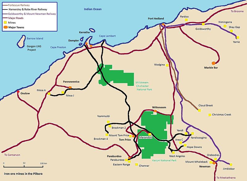
Not much I can add on implications of this for markets. Roughly speaking it looks like BHP, FMG and AGO are more in the line fire in that they use Port Hedland. Most actual mines are far enough inland to avoid the worst of it you would think:

Hopefully folks and infrastructure will be safe.

